


Weather & Tides
Weather
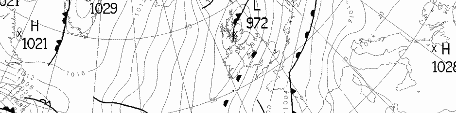
Met Eireann (www.weather.ie) – the Irish National Meteorological Service, and is the leading provider of weather information and related services for Ireland. It also supplies the Sea Area Forecast. Dun Laoghaire lies between Howth Head and Wicklow Head on the accompanying map.
The Commissioners of Irish Lights (based here in Dún Laoghaire Harbour) have equipped a number of aids to navigation with meteorological and oceanographic (MetOcean) sensors and transmit their data to Irish Lights headquarters via AIS. One of these is the “Dublin Bay Bouy“, a type 1 Safe Water Mark situated in Dublin Bay between Howth and Dun Laoghaire, which broadcasts detailed sea state and weather information on Twitter approx every 15-20 minutes.
WindGuru weather for Dun Laoghaire (be aware that if you use the free version the forecast may be a number of hours our of date).
Tidal Information
The tide turns at Dún Laoghaire harbour approx 4 minutes before high/low water at the North Wall in Dublin Port. The main flow in the Irish Sea is to flood North and ebb South, and the complex streams within the bay also follow this basic principal.
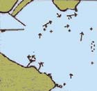
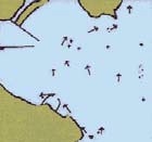
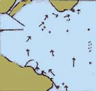
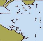
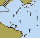
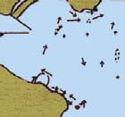
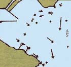
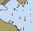
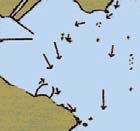
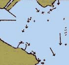
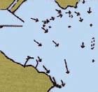
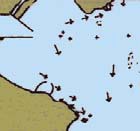
You can download the above guide to the Tidal Streams for Dublin Bay & Dun Laoghaire as a pdf (produced by Dun Laoghaire Harbour Company), as well as a detailed Guide to the Submarine Morphology of Dublin Bay by A Dowling (deceased), and find tide times on Sailing.ie.
tidal_stream_data_high_resDún Laoghaire Harbour Weather Station – live weather from the meteorological station on the ferry terminal roof.